|
 The Boat
The Crew
Journal
Weather
Links
Home
|
| |
Below are some of the more useful weather links that we relied on during
our coastal passages:
 North America Surface Analysis (NWS)
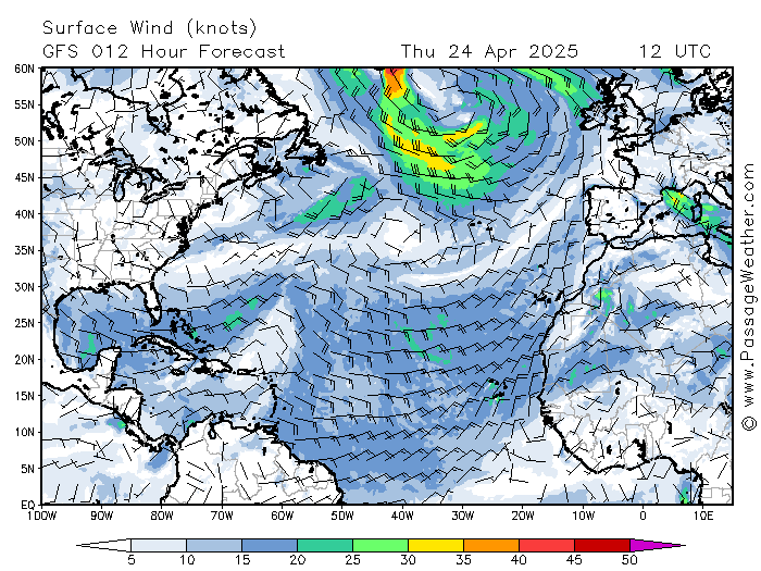
Atlantic Weather Summary (PassageWeather)
Worldwide Weather (PassageWeather)
Worldwide GRIBs (EURO & GFS)
Reporting Buoys
Surface
Wx Analysis (N. Atlantic [0000 Z]),
[0600]),
[1200]),
[1800])(NOAA)
Surface
Wx Forecast (N. Atlantic [24 Hour],
[48 Hour],
[96 Hour])
500 mb
Wx Analysis (N. Atlantic [0000 Z]) (NOAA).
500 mb
Wx Forecast (N. Atlantic [48 hour]),
[96 hour])
Sea State
Analysis for N. Atlantic ([0000 Z],
[1200 Z])(NOAA)
Sea State Forecast for N. Atlantic ([24 hour],
[48 hour],
[96 hour])(NOAA)
Gulf Stream
(Mid Atl),
(SE Atl)
NOAA Hurricane Forecast
Hurricane Models and more
El Niño Discussion
NOAA Coastal Weather Text(T):
|
CHS Maritimes (S,
F,
E
W)
|
|
Caribou, ME (T)
|
Gray, ME (T)
|
Tauton, MA (T)
|
New York, NY (T)
|
|
Philadelphia, PA (T)
|
Washington, DC (T)
|
Wakefield, VA (T)
|
Morehead City, NC (T)
|
|
Wilmington,NC (T)
|
Charleston, SC (T)
|
Jacksonville FL (T)
|
Melbourne FL (T)
|
|
Miami FL (T)
|
Key West, FL (T,)
|
Puerto Rico(T,)
|
Bahamas(T)
|
|
|
Bermuda( T,
T)
|
NOAA Offshore Weather Text(T):
Gulf of Maine to Hague Line (T)
Mid Atlantic (T)
SW & Tropical N. Atlantic (T)
NOAA High Seas Weather Text(T):
Western North Atlantic (T)
Caribbean (T)
|
|
|
![Surface Wx Analysis (N. Atlantic [0000 Z])](https://ocean.weather.gov/shtml/pyaa02bw.gif)
![[0600])](https://ocean.weather.gov/shtml/pyaa04bw.gif)
![[1200])](https://ocean.weather.gov/shtml/pyaa06bw.gif)
![[1800])](https://ocean.weather.gov/shtml/pyaa08bw.gif)
![Surface Wx Forecast (N. Atlantic [24 Hour]](https://ocean.weather.gov/shtml/ppae00bw.gif)
![[48 Hour]](https://ocean.weather.gov/shtml/qdtm85bw.gif)
![[96 Hour])](https://ocean.weather.gov/shtml/pwam99bw.gif)
![500 mb Wx Analysis (N. Atlantic [0000 Z])](http://tgftp.nws.noaa.gov/fax/PPAA50.gif)
![500 mb Wx Forecast (N. Atlantic [48 hour])](http://tgftp.nws.noaa.gov/fax/PPAI50.gif)
![[96 hour])](http://tgftp.nws.noaa.gov/fax/PPAM50.gif)
![Sea State Analysis for N. Atlantic ([0000 Z]](http://tgftp.nws.noaa.gov/fax/PWAA88.gif)
![[1200 Z])](http://tgftp.nws.noaa.gov/fax/PWAA89.gif)
![Sea State Forecast for N. Atlantic ([24 hour]](http://tgftp.nws.noaa.gov/fax/PWAE98.gif)
![[48 hour]](http://tgftp.nws.noaa.gov/fax/PJAI98.gif)
![[96 hour])](http://tgftp.nws.noaa.gov/fax/PJAM98.gif)